Property Record
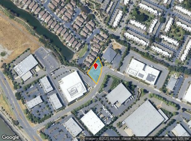
2331 N Loop Rd, Alameda, CA 94501
NEARBY LISTINGS FOR SALE OR LEASE
Property Detail
2331 N Loop Rd
Oakland-Fremont-Berkeley, CA
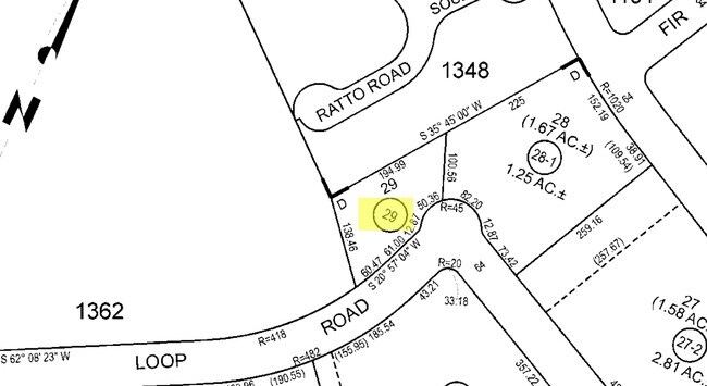
Parcel Map 5274
074-1337-029-00
LOT: 00029 BLK: PM: 0176 PAGE: 0004
Commercialacreage
Alameda
X
California
06001C0251H
0.45 AC
2024
Alameda
2025
East Bay/Oakland
427900
DEMOGRAPHICS near 2331 N Loop Rd
1 Mile
3 Mile
5 Mile
2024 Total Population
11,311
52,518
310,299
2029 Population
10,956
50,939
299,926
Pop Growth 2024-2029
(3.14%)
(3.01%)
(3.34%)
Average Age
44
44
40
2024 Total Households
3,989
20,530
105,982
HH Growth 2024-2029
(3.41%)
(3.30%)
(3.49%)
Median Household Inc
$194,962
$122,433
$76,356
Avg Household Size
2.80
2.50
2.70
2024 Avg HH Vehicles
2.00
2.00
2.00
Median Home Value
$1,039,753
$1,057,145
$788,526
Median Year Built
1982
1963
1955
Nearby Places
Map Layers
Map Styles
 Street
 Aerial
- Restaurants
- Banks
- Shops
- Fitness
- Groceries
PUBLIC TRANSPORTATION
COMMUTER RAIL
Oakland (Capitol Corridor - Amtrak, Coast Starlight - Amtrak, San Joaquins - Amtrak)
DRIVE
WALK
Distance
Oakland (Capitol Corridor - Amtrak, Coast Starlight - Amtrak, San Joaquins - Amtrak)
15 min
7.9 mi
AIRPORT
Metro Oakland International
DRIVE
WALK
Distance
Metro Oakland International
4 min
2.1 mi
San Francisco International
DRIVE
WALK
Distance
San Francisco International
44 min
33.1 mi
Freight Ports
Port of Oakland
DRIVE
WALK
Distance
Port of Oakland
16 min
8.4 mi
Nearby Properties
Address
Land Use
TOTAL SIZE
Lot Size
Zoning
Address
Land Use
TOTAL SIZE
Lot Size
Zoning
Address
Land Use
TOTAL SIZE
Lot Size
Zoning
219,200 SF
5.49 AC
Address
Land Use
TOTAL SIZE
Lot Size
Zoning
259,247 SF
5.44 AC
R5PD
Address
Land Use
TOTAL SIZE
Lot Size
Zoning
165,923 SF
14.99 AC
Address
Land Use
TOTAL SIZE
Lot Size
Zoning
190,786 SF
3.75 AC
Address
Land Use
TOTAL SIZE
Lot Size
Zoning
128,650 SF
6.38 AC
Address
Land Use
TOTAL SIZE
Lot Size
Zoning
180,959 SF
9.38 AC
Address
Land Use
TOTAL SIZE
Lot Size
Zoning
374,725 SF
18.63 AC
Address
Land Use
TOTAL SIZE
Lot Size
Zoning
336,680 SF
9.93 AC
M40
Address
Land Use
TOTAL SIZE
Lot Size
Zoning
284,255 SF
5.07 AC
Address
Land Use
TOTAL SIZE
Lot Size
Zoning
200,238 SF
9.28 AC
Address
Land Use
TOTAL SIZE
Lot Size
Zoning
138,196 SF
8.47 AC
Address
Land Use
TOTAL SIZE
Lot Size
Zoning
155,000 SF
8.41 AC
Address
Land Use
TOTAL SIZE
Lot Size
Zoning
93,964 SF
24.21 AC
Address
Land Use
TOTAL SIZE
Lot Size
Zoning
76,114 SF
6 AC
Address
Land Use
TOTAL SIZE
Lot Size
Zoning
197,321 SF
16.52 AC
Address
Land Use
TOTAL SIZE
Lot Size
Zoning
213,600 SF
10.60 AC
Address
Land Use
TOTAL SIZE
Lot Size
Zoning
1,189,534 SF
26.64 AC
Address
Land Use
TOTAL SIZE
Lot Size
Zoning
100,909 SF
6.70 AC
Address
Land Use
TOTAL SIZE
Lot Size
Zoning
121,597 SF
5.75 AC
Address
Land Use
TOTAL SIZE
Lot Size
Zoning
204,006 SF
6.39 AC
M40
Address
Land Use
TOTAL SIZE
Lot Size
Zoning
80,810 SF
5.62 AC
Address
Land Use
TOTAL SIZE
Lot Size
Zoning
86,973 SF
2.92 AC
Address
Land Use
TOTAL SIZE
Lot Size
Zoning
132,446 SF
4.34 AC
Address
Land Use
TOTAL SIZE
Lot Size
Zoning
93,100 SF
24.21 AC
Address
Land Use
TOTAL SIZE
Lot Size
Zoning
6.81 AC
Address
Land Use
TOTAL SIZE
Lot Size
Zoning
60,846 SF
3.75 AC
Address
Land Use
TOTAL SIZE
Lot Size
Zoning
152,535 SF
1.86 AC
Address
Land Use
TOTAL SIZE
Lot Size
Zoning
95,670 SF
1.95 AC
Address
Land Use
TOTAL SIZE
Lot Size
Zoning
66,157 SF
7.68 AC
The World's #1 Commercial Real Estate Marketplace
Connect with us
© 2026 CoStar Group
The information above has been obtained from sources believed reliable. While we do not doubt its accuracy we have not verified it and make no guarantee, warranty or representation about it. It is your responsibility to independently confirm its accuracy and completeness. Any projections, opinions, assumptions, or estimates used are for example only and do not represent the current or future performance of the property. The value of this transaction to you depends on tax and other factors which should be evaluated by your tax, financial, and legal advisors. You and your advisors should conduct a careful, independent investigation of the property to determine to your satisfaction the suitability of the property for your needs.